 Driving up the south coast from Dingle
Next day we took off to the tip of the Dingle peninsula, which is a wild wind swept promontory with some old pre-historic 'beehive' houses, stone houses lasting from the Irish potato (spud) blight famine, and scattered villages set in the green rolling countryside over the craggy cliffs above the tossing seas.
 Map pf the three peninsulas of south western Ireland
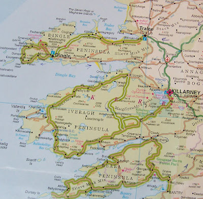
Above is a map of the three peninsulas so you can see roughly the roads we took, except for the fact that on the Iveragh peninsula inland there are heaps of country lanes not shown which led to it being a literal maze of indistinguishable routes in the centre.
 Map pf the three peninsulas of south western Ireland
Above is a map of the three peninsulas so you can see roughly the roads we took, except for the fact that on the Iveragh peninsula inland there are heaps of country lanes not shown which led to it being a literal maze of indistinguishable routes in the centre.
 Further towards the tip of Dingle peninsula
 NZ cabbage trees are all over Ireland
 A row of 'potato famine' cottages
 A traditional stone ford
 Remains of prehistoric beehive houses
 Coming to the last corner before the final spit
 A shrine at the corner
 Three images of the road into the final bay
 The little beach cove at the turning point
 Panorama from the beach
 The islands and craggy peninsulas on the north face
There were a few more ancient ruins, Gallarus oratory believed to be a 6th to 9th century Christian church and Ballinskelligs Priory. On the way back we got lost on little side roads that snaked all over the north side through farming hamlets and ended up about 8 kms north at the wild little fishing wharf at Brandon Heads.

 Turning back inland
 Ballinskelligs Priory

 An accidental detour to the little fishing harbour at Brandon Heads
If that wasn't enough, we then drove on back down the south side of the Dingle peninsula to the Iveragh peninsula containing the Ring of Kerry. Instead of going round the ring, we decided to go over the very tiny road across the mountains through the Ballagbeama Gap. This took off cleanly enough from Killorglin and the road wound up a valley to a ridge crossing into forests in the interior past a little lake, or lough, or loch.
 Iveragh (Kerry) peninsula from the south side of Dingle peninsula.
Three views of Killorglin


 The coast road (wrong way for us)
 Lough Acoose
But then chaos struck. What was one little scenic connecting road on the map turned into a rabbit warren of unsignposted lanes, leading in every direction. Other Irish travelers were as lost as we were and we met them several times driving in short circles and asked one another directions. Finally, after making it to Glencar and asking a local with an exceedingly broad Irish accent, which we could barely decipher, we passed another three or four unmarked crossings and entered what looked like a deserted farm track which nearly petered out.
 Stopping to ask the way at Glencar
 Getting nearer the gap
 Is this the right road?
 Is this one any more then a farm track
But then became a very narrow tar sealed road which snaked around, winding up to the Ballagbeama Gap, a precipitous little pass leading eventually through through more ambiguous turnings to Kenmare.

 Ballaghbeama Gap
 The summit
 Then road down
On our arrival in Kenmare, it again perfidiously rained and we ended up noticing by accident a sign saying 'Private Hostel 50 m' and staying there with a lone 75 year old Irish woman for the grand sum of 30 Euros.


 The owner of the "Private Hostel"
We began the next day making a short trip up the coast of the Beara peninsula before deciding to travel on south to Cork and Kilkenny to avoid time running out before we made it back to Dublin for our flight out.

 Two views along the coast of the Beara peninsula
 Three ancient stone circles, this on the Beara peninsula

 The druid's outlook on the road south on Beara
 Druid's outlook stone shop
No comments:
Post a Comment